June 24, 2008
Screencast: Loreto Bay Agua Viva Layer in Google Earth
A couple of days ago I released the Loreto Bay Agua Viva Layer for Google Earth (click here to access it).
Click on image above for tutorial (13 minutes, 150 MB)
In this screencast I explain how you can easily download and install Google Earth and then check out the Loreto Bay Agua Viva Layer.
I heard that Loreto Bay has some kind of map application in its web site. Since that application is only available to LB owners, I decided to create this Agua Viva Layer for Google Earth. I don't know how good the Loreto Bay map is or how it compares to Google Earth - but our Agua Viva layer is free and available to anyone. See the tutorial below for more details.
Screencast: Loreto Bay Agua Viva Layer in Google Earth
Update: unfortunately, the ning.com community site where I hosted this tutorial, is no longer available. I may re-process the video and upload it at some point, but for now this tutorial is no longer available.
Find more videos like this on Loreto Bay Community
June 23, 2008
Loreto Bay Layer in Google Earth
I have released a layer of Loreto Bay's Founders' and Agua Viva neighborhoods that can be used in Google Earth -
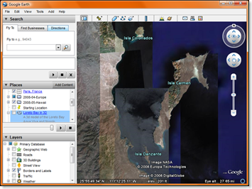
Install Google Earth, then click the image
If you don't already have it, download and install the free application "Google Earth" from http://earth.google.com/. Then click on the image above to open the Loreto Bay Layer for Google Earth. If you are new to Google Earth, check out this tutorial.
History
- 6/28/2008: Added the Founders' Neighborhood layer, 20080628-Loreto-Bay-in-3D.kmz, 3.6 MB.
- Added the Founders' Neighborhood layer on a suggestion from Drew McNabb (FN 49) - thanks Drew!
- Now we have maps for both the Founders' Neighborhood and half of Agua Viva.
- Renamed this article the "Loreto Bay Layer in Google Earth".
- 6/24/2008: Released a tutorial that explains some of the features of Google Earth and the Agua Viva layer. Check it out here.
- 6/23/2008: First version released, 20071118-Loreto-Bay-in-3D.kmz, 1.8 MB. Included:
- Agua Viva Layer for Google Earth.
- 3D Model of Casa Brasil (the house we hope to build, located on our lot in Nopolo).
- AV 61 - with a picture of the owners, Barry and Patricia.
June 21, 2008
Loreto Hotel Association
The Loreto Hotel Association has a new web site - to check it out, point your browser to:
http://www.gotoloreto.com/

The site is fairly simple, it looks like a basic HTML web site you may have seen back in 1998. But the content is pretty good: it has an updated list of restaurants, information on Hotels and places to visit, activities and more.
Note to the gotoloreto.com designer: don't use images to display content such as addresses and phone numbers. Instead just use HTML and cascading style sheets (CSS), the information will look just as good, but visitors to the site will be able to copy and paste the data.