September 4, 2007
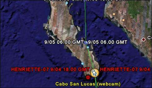
Just a quick Internet/computer tip. We are following hurricane Henriette and thinking of everyone in Todos Santos and Loreto. If you have an Internet connection you can track the storm live by using these links:
1) Install Google Earth if you don't have it: http://earth.google.com/download-earth.html
2) Use this link to track Henriette's position live: http://bbs.keyhole.com/ubb/download.php?Number=110283

---------- Forwarded message ----------
From: Emmanuel Huna
Date: Sep 4, 2007 6:59 PM
Subject: Re: Tracking storms in Google Earth
To: Friends and Family
Here's an article that explains the storm tracking feature in Google Earth:
http://www.gearthblog.com/blog/archives/2006/09/new_storms_-_hurricane_gordon_typhoon_shanshan.html
You can use Google Earth to track all current tropical storms by using this excellent storm tracker by 'glooton' which was posted at the Google Earth Community. This uses a network link to automatically show you the most current storms world-wide by scanning weather sources on the Internet. It shows you the past track and the forecasted path, and icons indicating strength of the storm. It also shows you the web cam locations/pictures for towns near an approaching storm, wind strengths, satellite photos, and more. There is another hurricane tracker (for Atlantic storms) which shows model forecast tracks, satellite photos, and other data. This was done by Paul Seabury and posted at the GEC as well. Also, Paul's network link now includes some interface enhancements if you use GE 4. Also, check out these and other weather tools put together by Google Earth Blog.
You'll need to click on the "Hurricanes lives positions" to refresh the positions of the storms (you'll see the animated icon as Google Earth retrieves data through the net). Move "Hurricanes lives positions" to "My Places" if you'd like to keep it - you can always turn it on or off by checking or unchecking it. Play with the checkboxes under the storm you're tracking to turn on or off satellite images, radar, etc...
Emmanuel