December 31, 2006
A hospital in Loreto
While we stayed at the Inn at Loreto Bay in Loreto, Mexico, a couple of months ago, there was a video playing on the hotel's internal system describing the "Loreto Bay Foundation". It's a promotional video for Loreto Bay (www.loretobay.com) and contains a lot of good information on the foundation.
I apologize for the quality of the video, but the only way I could get it recorded was by manually using a hand-held camera. The sound came out ok.
Below I have a few comments on the Loreto Bay Foundation and its donations to create a medical center in Loreto.
We learn a few things from the video:
1) If you purchase a property in Loreto Bay, 1% of the sales goes to the Loreto Bay Foundation. They have over $350 million dollars in sales already, so the foundation probably has 3.5 million dollars.
2) The Loreto Bay Foundation has given the governor of Baja California Sur $350,000 dollars as "seed" money to start building a "medical center", or a hospital, in Loreto. The nearest hospital is currently in La Paz, a four hour drive of Loreto.
It's clear that Loreto Bay's motives are not completely altruistic: the majority of their customers, purchasing the condos and houses, are retired folks who are probably very worried about the lack of modern medical facilities in Loreto.
But who cares if their motives are not 100% pure? Loreto Bay is a business, a corporation who needs to make a profit. But they have goals of sustainable living and the local community will end up with at least a new hospital.
That's pretty amazing and Loreto Bay deserves recognition and support.
Information on the town of Loreto
Did you know that 240 years ago, Loreto was the capital of both Californias (Baja California and the American State of California)? I found an article on Wikipedia on the town of Loreto, Baja California Sur, Mexico - check out:
See also this article on the mission of Loreto, a building which still stands and is used as a church even today:
Below I copy the current information on Loreto.
Loreto, Baja California Sur
From Wikipedia, the free encyclopedia
http://en.wikipedia.org/wiki/Loreto%2C_Baja_California_Sur
Loreto (or Conchó) was the first Spanish town on the Baja California Peninsula. It served as the capital of Las Californias from 1697 to 1777, and is the current seat of the municipality of Loreto in the Mexican state of Baja California Sur. The town of about 10,000 people is located on the coast of the Sea of Cortés, about 350 km (220 miles) north of the state capital, La Paz.
The town was founded in 1697 by Jesuit missionaries. The Misión Nuestra Seńora de Loreto was founded in the town in 1752. The town served as the capital of the province of Las Californias from its founding until the capital was moved to Monterey on February 3, 1777. The town then became the headquarters for the Lieutenant Governor of California Viejo (later the province of Baja California).
The town is now a tourist resort, catering mostly to U.S. travelers, with daily flights from the U.S. state of California arriving at Loreto International Airport. Many of the American Tourists enjoy fishing in "pongas" for "dorado" (Mahi-mahi or Dolphin Fish). Local restaurants will even prepare the daily catch of the tourists. Loreto has an excellent museum alongside the historic, but still active, parish. The Spanish Fathers found a steady spring of fresh water on this site. The town has an active sister city relationship with Hermosa Beach, California and Cerritos, California, USA.
Articles on Agua Viva: Summary
I have published a few articles related to the Loreto Bay Agua Viva neighborhood. Here's a summary:
1) Start by reading up on what will be the Agua Viva Neighborhood.
2) Watch a video that describes Agua Viva: part 1 here and part 2 here.
3) See how close the Agua Viva neighborhood will be to our lot.
This is cool stuff.
Agua Viva Neighborhood (Part 2 of 2)
This is part 2 of 2 of a promotional video for Loreto Bay and contains a lot of good information on the Agua Viva Neighborhood and what they are trying to accomplish.
I apologize for the quality of the videos, but the only way I could find to get a copy of them was by manually recording the video stream through a hand-held camera. The sound came out ok.
I broke into two parts of roughly 3.5 minutes each, this is part 2 of 2; click here for part 1.
See also the following: information on the Agua Viva Neighborhood and how close our lot is to Agua Viva?.
Agua Viva Neighborhood (Part 1 of 2)
While I stayed at the Inn at Loreto Bay a couple of months ago, there was a video playing on the hotel's internal system describing Agua Viva. It's a promotional video for Loreto Bay and contains a lot of good information on Agua Viva and what they are trying to accomplish.
I apologize for the quality of the videos, but the only way I could find to get a copy of them was by manually recording the video stream through a hand-held camera. The sound came out ok.
I broke into two parts of roughly 3.5 minutes each, this is part 1 of 2; click here for part 2.
See also the following: information on the Agua Viva Neighborhood and how close our lot is to Agua Viva?
How close is our lot to Agua Viva?
I have created a picture that shows how close our lot is in relation to Loreto Bay and the Agua Viva neighborhood:
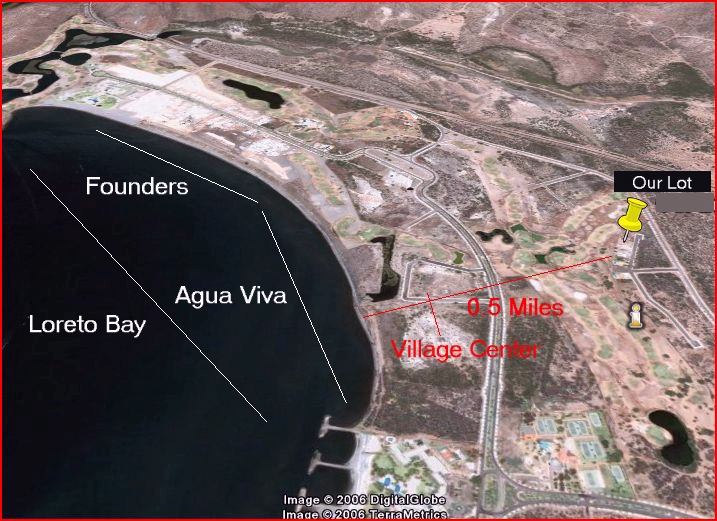
Notice that our lot is less than half a mile from the water (Sea of Cortez) and only a fairway in the golf course separates us from the Agua Viva neighborhood.
For more information on the Agua Viva neighborhood in Loreto Bay, click here. I also published a promotional video from Loreto Bay that describes Agua Viva, click here for part 1 and here for part 2. Below I also publish a plan of the Agua Viva neighborhood and information on the "Village Center".
Map of Agua Viva
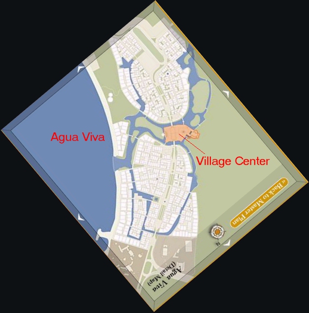
The map above is found on the LoretoBay.com web site and represents what the neighborhood will look like once the work is complete.
Notice that what they called the "Village Center" (in orange above) is right across the golf course from our lot. Here's more information on the Village Center:
If you'd like to learn more about the different neighborhoods in Loreto Bay, click here for the Loreto Bay Master Plan - they did a good job of using Flash to easily allow for an interactive map.
Loreto Bay, Agua Viva Neighborhood
Loreto Bay has started selling units on their second neighborhood, called "Agua Viva", or "Living Water" in Spanish.
Below I copy information on this second neighborhood. I have also published a couple of videos on Agua Viva and a map that shows the location of our lot in relation to Agua Viva - see this summary article for details.
Loreto Bay Homes
Phase 2 - Agua Viva
http://www.loretobay.com/cms/page1205.cfm
Phase 2 of The Villages of Loreto Bay will be Agua Viva or "Living Water." Like Founders’ Neighborhood, Agua Viva offers a variety of home designs, including courtyard homes, luxury condominiums, beachfront and golf course custom homes. This neighborhood is a vibrant confluence of human habitation, the Sea of Cortés, and a series of regenerated estuaries.
Agua Viva has all the ingredients of a great historical village. There is an old world Mexican charm in the narrow, sinuous streets connecting to sunlight in courtyard after courtyard. Moving from shadow to splashes of light, refreshing fountains of water, vibrant colors, and the fragrance of bougainvillea – all the senses are invigorated
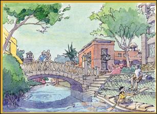
Here you’ll find homes with close ties to the water, where backyards become estuaries and the Sea of Cortés is always just steps away. Many of these soft-edged estuaries and more structured canals will commence their five mile, meandering journey through Loreto Bay in Agua Viva. These waterways will offer delightful kayaking opportunities, (in many cases, right from your home!) and will provide a refuge and/or nursery for an array of marine life and water fowl adding to the kayak experience.
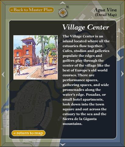
The Village Center is an island located where it all flows together. Cafes, studios and galleries populate the edges of this vibrant village center and golfers play through the center of the village like the best of Europe’s old world courses. There are performance spaces, gathering spaces, and wide promenades along the water’s edge. Posadas, or small hotel apartments, look down into the town square and out across the estuary to the sea and the Sierra de la Giganta mountains.
Agua Viva is a place where estuaries will continue to regenerate the habitat for fish, crustaceans and birds, all feeding and sustaining the sea. Constructed canals are designed in Agua Viva to regenerate native mangrove forests and the rich marine and bird life they support. Agua Viva will be a place where canals wind through walkable neighborhoods.
Learn more about becoming a home owner to share in this unique community.
See our lot in Google Earth
I have link that will allow you to see our lot in Google Earth. If you have Google Earth installed, click on the link below:
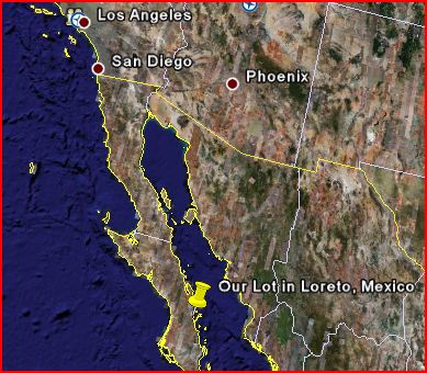
View our lot in Loreto, Mexico, in Google Earth
If you don't have Google Earth, get it. It's an amazing application from Google that allows you to see the earth in 3D. Here's how they describe it:
Google Earth streams the world over wired and wireless networks enabling users to virtually go anywhere on the planet and see places in photographic detail.This is not like any map you have ever seen. This is a 3D model of the real world, based on real satellite images combined with maps, guides to restaurants, hotels, entertainment, businesses and more. You can zoom from space to street level instantly and then pan or jump from place to place, city to city, even country to country.
Get Google Earth. Put the world in perspective.
To download the free Google Earth, point your browser to: http://earth.google.com. Once you have downloaded and installed Google Earth, I copy below a tutorial that will show you in a few minutes how to use most of its features to see some great views of your favorite spots (your house or maybe our Loreto lot?).
Important Basics for Google Earth
Google Earth Blog, Link
If you are new to Google Earth (GE), or looking for ways to improve how you interact with GE, then this entry may be of help. Additional resources are referenced below. Note: this blog entry assumes you are using Google Earth 4 - see this for GE version 3 oriented tips.
Learning to manipulate the mouse and keys to control GE is crucial to getting the most out of sightseeing the Earth. The first important thing to know is how to zoom in closer to the Earth. You have many ways to do this: double-click your mouse button (left button, if you have multiple buttons, to zoom in, right button to zoom out); use the mouse scroll-wheel (if you have one); or use the CTRL-UP or CTRL-DOWN key combinations. You can also use the navigation gadgets - the "+" and "-" buttons with slider on the far upper-right to change your altitude. The mouse scroll-wheel is probably the favorite method of most typical GE fans. All of these methods adjust your altitude above the Earth's surface. You can see your height above sea level in the lower right of the GE viewing window. You can move the Earth to position it where you want to see by clicking a point with the left mouse button and slide the cursor to the middle of the viewing window.
At first, many people don't realize Google Earth is much more than a map with aerial and satellite photos attached. GE uses data from NASA Space Shuttle missions which provides 3D terrain data for the entire land surface of the Earth. Let's demonstrate this.
Click on this link to go to GE and fly to Mount St. Helens. Beautiful view right? But, try this: hold your PAGE DOWN key on your keyboard and watch GE tilt your view so you can see Mount St. Helens as a 3D mountain (if you don't - check to see that the "Terrain" layer is turned on). Very cool right? PAGE UP will tilt your view back up. You can also use the slider control at the upper right of the navigation control for tilting. A nice tip: hit the "u" key to tilt back straight up automatically. The "r" key will reset to north and tilt up.
An easier way to tilt and pan your view is to click and hold the middle mouse button or scroll wheel button (those of you who have a Mac with one mouse button have to use the above key or navigational control techniques - but, I would recommend getting a 3-button mouse). While you're holding the middle button if you move your mouse forward and backwards it will tilt the view. Side to side will pan your view around the point you are looking at. Holding the SHIFT key will constrain your tilt and allow you to rotate your view about a point.
Related Resources:
GE 4 User Guide
Google Earth Basics by Google Earth Blog
Using Google Earth - Blog by a Google Earth documentation specialist
Common Questions About GE
SpaceNavigator - An advanced 3D mouse device for GE
Pictures of the Lot
In December 2005, Joe, Sandy, Janelle and I went down to Loreto. It was a vacation but we were also looking to purchase some property down there.
We found the lot in Nopolo, right in the middle of what will be Loreto Bay and we fell in love with it. You can see some pictures I took of the lot then:
http://pictures.ehuna.org/v/public/lot/
Note: the pictures above are public. But you will need a username and password to access many other albums. If you are a friend or family and you'd like to see other albums on http://pictures.ehuna.org shoot me an email (you might find yourself in one or more of these password protected pictures).
Video of the Lot
I have created a video that shows the location of our lot - see below:
The video shows how the lot is located on the Loreto Golf course, near the mountains, but only half a mile from the Sea of Cortez and the Inn at Loreto Bay.
Rolling Doors and Grilles
Janelle had a good idea to protect the house: rolling doors or sliding grilles. Here's a web site with samples:
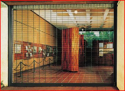 Cookson Company Rolling Doors and Grilles
This will allow us to keep the house safe while we're away and can even be used by guests at night to make them feel more secure.
Where In The World Is Nellie?
I just found the following blog:
http://whereintheworldisnellie.blogspot.com/
It's an interesting site with articles from Nellie, who seemed to have worked for Loreto Bay but now has opened her own business in Loreto.
Loreto Bay
One of the main reasons we decided to build a vacation home in Loreto is the "Loreto Bay" project. In their own words:
Situated on 8,000 acres on the shores of the Sea of Cortés, The Villages of Loreto Bay will be a seaside community of approximately 6,000 homes with mixed-use buildings, narrow, walkable streets and authentic Baja architecture that exists in harmony with its surroundings.
The Loreto Bay project will be divided in 7-8 neighborhoods. They have almost finished the first neighborhood, called "The Founders Neighborhood", and are starting on the second, called "Agua Viva". Our lot is located right in the middle of where the 4th neighborhood will be built, right across from Agua Viva on the golf course.
For more information on Loreto Bay, see:
Last we heard, Loreto Bay had sold over $350 million dollars and over 700 units.
New site!
This is a test post to see if http://loreto.ehuna.org is properly setup. This is exciting stuff.